
Microsoft's Defense System demo leveraged Esri software to enable AI and augmented reality for field missions
NewsJune 13, 2019

REDLANDS, CALIFORNIA. Microsoft?s Tactical Edge Platform is using Esri?s ArcGIS Enterprise to enable its Microsoft Azure and Azure Cognitive Services to have a geographic context via Esri?s advanced mapping and spatial analytics technology. The platform is targeted at defense and intelligence professionals to demonstrate how they can use connecting field sensor data and cloud services for tactical field operations or for domestic emergency response.
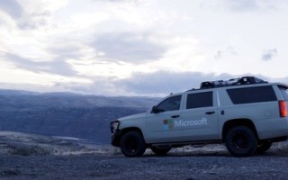
This demonstration is displayed by deploying the platform in an operational car Microsoft calls the Tactical Edge Vehicle.
Warfighters or first responders to disasters, equipped with mobile phones that act as autonomous ground sensors, can capture the seen and unseen world around them with elements ranging from wireless infrastructure to images of the population. That data is then transmitted to ArcGIS, residing in Azure and leveraging Azure Cognitive Services to apply artificial intelligence (AI) to the collected data. The AI-processed results are merged with ArcGIS’s spatial analytics, and become actionable across the ArcGIS platform, including pushing results forward into the tactical vehicle’s displayed ArcGIS Operations Dashboards. Operations Dashboards can be quickly generated by anyone and custom built for all roles in a mission.
“Esri’s cloud-based platform enables networks of sensors to be analyzed geospatially, and coupled with Microsoft Azure Cognitive Services, allows for that sensor information to be analyzed around the clock supporting various roles from the edge to the intelligence centers,” said Lily Kim, General Manager, Azure Global at Microsoft.
Cloud computing has enabled more versatile and efficient ways of deploying technology to various types of work environments and infrastructures by freeing organizations from reliance on a central server.
Leveraging the open-standards of these commercial off-the-shelf (COTS) products immediately connects ArcGIS compatible partners through ArcGIS to Azure and can be used by the tactical vehicle. In this demonstration, it includes Knowledge Bridge International (KBI) for the sensor network, and Meemim’s vGIS utilizing Microsoft Hololens. Both KBI and Meemim are among the hundreds of Esri partners.


