Georgia Tech Research Institute lidar project
StoryJanuary 27, 2015
In this new University Update section of Military Embedded Systems magazine, we will be focusing on one military-related university project per issue. This issue focuses on the Georgia Tech Research Institute (GTRI) lidar project. The GTRI research and development program’s goal is to produce a smaller, lightweight, real-time bathymetric lidar that can be deployed on unmanned aerial vehicles (UAVs) rather than the heavy manned vehicles they currently require, cutting cost and time. In the following Q&A, we spoke with Grady Tuell, the developer of GTRI’s lidar technology and the principal research scientist leading the work. Edited excerpts follow.
In this new University Update section of Military Embedded Systems magazine, we will be focusing on one military-related university project per issue. This issue focuses on the Georgia Tech Research Institute (GTRI) lidar project. The GTRI research and development program’s goal is to produce a smaller, lightweight, real-time bathymetric lidar that can be deployed on unmanned aerial vehicles (UAVs) rather than the heavy manned vehicles they currently require, cutting cost and time. In the following Q&A, we spoke with Grady Tuell, the developer of GTRI’s lidar technology and the principal research scientist leading the work. Edited excerpts follow.
MIL-EMBEDDED: Can you give me some background information on bathymetric lidars in general?
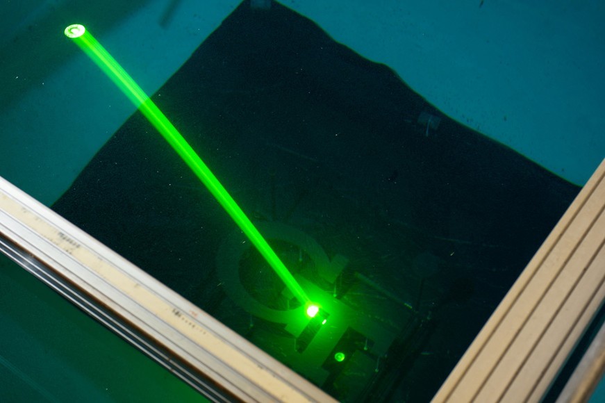
TUELL: Bathymetric lidars are a specialized version of airborne lidars. Typically, they employ green lasers for penetrating the water (as opposed to infrared lasers most often used in topographic applications), and high-speed, high dynamic range detector architectures to produce waveforms representing the intensity of the reflected light from the complete optical path from the airplane to the seafloor (see Figure 1). Signal processing software is used to decompose these waveforms into the “in air” and “in water” distances. These distances are then used with the appropriate pointing angles to compute coordinates on the sea surface and the seafloor. If the lidar is radiometrically calibrated, these waveforms can also be radiometrically inverted to estimate seafloor reflectance at the lidar wavelength, and these estimates of reflectance can be used to generate 3-D images of the seafloor. Most bathymetric lidars are also capable of mapping the beach and therefore simultaneously map the topography and bathymetry of the coastal zone.
Figure 1: The Georgia Tech Research Institute (GTRI) lidar prototype uses green lasers to penetrate the water as opposed to infrared lasers.
(Click graphic to zoom by 1.9x)
|
|
MIL-EMBEDDED: What is the ultimate goal of the GTRI’s new approach for lidar?
TUELL: GTRI’s research and development program is designed to produce a smaller, lightweight, real-time bathymetric lidar deployable on UAVs. We are also pursuing the development of techniques to estimate total propagated uncertainty (TPU) in real time. TPU produces an estimate of the accuracy of each lidar point. If these accuracy assessments are produced in real time, operators immediately know if the collected data meet the accuracy requirements of the mission, and can then recollect the data if necessary before the aircraft moves on.
MIL-EMBEDDED: Can you explain the role of the Active Electro-Optical Intelligence, Surveillance, and Reconnaissance (AEO-ISR) project?
TUELL: AEO-ISR is a GTRI Internal Research and Development (IRAD) project. This IRAD investment is designed to leverage GTRI’s existing lidar infrastructure (established for building atmospheric lidars) toward building airborne lidar systems, and to specifically engage in the effort to build bathymetric lidars for deployment on UAVs. The effort has involved building geometric and radiometric simulators, development of appropriate receiver and detector architectures, development of a high-speed, lightweight circular scanner, and the development of the mixed mode computing architecture enabling the real-time computation of coordinates and TPU.
MIL-EMBEDDED: What are the latest developments on the project and what do you foresee for the future?
TUELL: We have continued to refine the design for an air-deployable version of the prototype and have integrated a geiger mode avalanche photodiode detector (GmAPD) into the pathfinder lidar. This integration has produced a hybrid linear mode waveform – GmAPD lidar. We are using this lidar to improve the accuracy of the raytracing through the water’s surface, and ultimately, the accuracy of the seafloor images. We are also pursuing the development of a real-time data fusion system. This work involves leveraging the real-time computing capability for the lidar to combine the lidar data with spectral images in real time. We believe this capability is important to ISR [intelligence, surveillance, and reconnaissance] applications ... specifically, detection of targets under forest canopies.
For more information, visit www.gtri.gatech.edu.