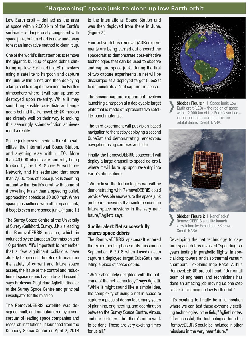
Small sats aim to provide on-demand tactical-level imagery for warfighters
StoryNovember 30, 2018

Raytheon is sending a one-of-a-kind small satellite to low Earth orbit to do a proof of concept of a prototype design - originally developed for the U.S. Defense Advanced Research Projects Agency (DARPA) - to provide useful imagery directly to military users in the field.
A small satellite called “SeeMe” – short for Space Enabled Effects for Military Engagements – is poised to bring on-demand tactical-level imagery directly to warfighters in the field. The small sat was designed and built by Raytheon as part of a U.S. Defense Advanced Research Projects Agency (DARPA) program, originally intended to be launched as a constellation of 24. When the program was canceled several years ago after the first phase, Raytheon decided to complete the SeeMe satellite on its own and built only one.
“The SeeMe satellite is about the size of a 5-gallon paint bucket and would fit easily on a desk chair,” says Buck Larkin, small space program manager for Missile Systems at Raytheon. “It weighs 22 kilograms (~50 pounds) and features a telescope that’s about 12 inches around. Since it’s a compact satellite, its size matches really well with our manufacturing here at Missile Systems.”
Part of the reason Raytheon decided to build SeeMe on its missile manufacturing line is because the satellite requires small electronics components and guidance sections – just like a missile – as well as sensors for star detection, geolocation, and GPS. “Small satellites need all of the same kinds of things that we’re used to working with here at Missile Systems, and we found that it matches really well with our test equipment,” Larkin explains. “We can build missiles one day, satellites the next.”
How long does it take to build one of these small satellites? “It’s hard to say right now, but as a rule of thumb, for small satellite assembly either on this program or one we did as part of the Operation Responsive Space for the U.S. Air Force Operationally Responsive Space (ORS) Office, we came to the conclusion that with one small satellite cell we could build about 20 per month if we get a large contract,” Larkin explains. “So about one per day, once we have all of the parts received and get up and running – they’re fairly quick to build.”
Environmental testing could potentially slow things down, he adds, because waiting for a thermal chamber to perform huge temperature swings takes time. But if more orders come in, Raytheon will simply get more thermal chambers and adapt the line to accommodate them.
The majority of the SeeMe satellite is crafted from commercial off-the-shelf (COTS) parts. “We custom-designed the telescope, but leveraged existing CubeSat parts for a lot of the components and used commercially available batteries, solar panels, and power-conditioning units. Even the image detector is COTS,” Larkin says.
The satellite’s telescope needs the ability to image at 350 kilometers and uses a commercial CMOS chip. Raytheon’s only real problem with designing and building it was that “it’s difficult to test it at the ground on a 350-kilometer range, but the design is robust and we’re confident it will work,” Larkin points out.
Using COTS for most of the rest of the satellite wasn’t without challenges, though: “Our challenge, as an embedded system, is that even though some parts claimed to adhere to a certain standard like RS-422 or any number of other standards, they sometimes use different pinout locations on their interface cards,” Larkin notes. “So one of the critical things our electronics folks had to do was to build a custom interface card to translate the different pinouts between commercial components so that Brand A could talk to Brand B, bridging the gap in standards. These CubeSat parts were built about five years ago and standardizing some of those interfaces has improved since then, but this was a challenge that resulted from buying from multiple vendors to get the lowest cost.”
Since the SeeMe satellite won’t be operating at an altitude with high radiation units, radiation hardening wasn’t as big of a concern as you might guess. “A lot of the parts we used are from CubeSats, and we ran a risk assessment on the other parts to determine which ones needed to be protected and which ones we didn’t,” Larkin says. “We made some cost/benefit trades and, in some cases, didn’t go with any redundant parts.”
SeeMe is scheduled for launch right before Thanksgiving 2018; if all goes as planned, it should be functioning and sending its first images Earthward a few days after launch.
“With all of the Google satellite imagery now available, anyone can just go to Google Earth or commercial websites to find imagery less than a day old, if they don’t mind paying subscription fees, but it’s not anything that troops in the field can use,” Larkin says. “So the real benefit we’re going to provide is instantaneous on-demand imagery directly to military users in the field. You have a satellite dedicated just to you. The really neat thing about it is that as the satellite comes over the horizon, a user can provide tasking to it – such as ‘tell me what’s over that hill’ – by giving it the coordinates to look at. The satellite acquires the tasking, turns and takes an image, then immediately starts downlinking it directly back to the user before it passes over the horizon and is out of view.”
This is a completely different concept than what normally happens for military users, because imagery typically gets sent to an imagery analyst in the rear, where it gets processed and is then sent forward again. “It’s all about getting tactical-level imagery for warfighters who don’t have any other options available,” Larkin says.
The main utility of this type of on-demand small-satellite imagery is that it provides users with the ability to access imagery in places where unmanned aerial vehicles (UAVs) can’t be flown, they’re not available, or they’ve been grounded for some reason. “It could be used in Afghanistan, Iraq, or any part of the world,” Larkin notes. “You can use it for commercial ventures, or maritime purposes for users who want to know if there any ships out there in its path that aren’t using transponders. It has applications beyond military ones.”
For years, the military has been closely watching the commercial small-satellite industry to determine where it might have applications that pertain to them, and Larkin says that there’s now enough data to show that small satellites are indeed useful. “We’ll see government interest in small satellites start to match commercial interest soon,” he adds.
The SeeMe satellite is expected to remain in orbit between one to five years, before eventually de-orbiting – without leaving any space debris behind.
Sidebar 1
|
|