GPS: Smaller, faster, jam-proof, and nearly everywhere
StoryDecember 17, 2013


Missile systems, Unmanned Aerial Vehicle (UAV) payloads, soldier radios, and other applications are seeing the benefits of miniaturization and enhanced performance in Global Positioning System (GPS) technology. However, GPS designs also require more elaborate anti-jamming techniques such as combining GPS with Inertial Measurement Units (IMUs) to combat new, sophisticated threats. Meanwhile, DARPA researchers continue to reduce GPS footprints as they combine a tiny IMU and timing capability on one substrate.
The original GPS satellite-based navigation system, operated by the U.S. Department of Defense (DoD) for military and general public use, consists of a network of 24 satellites orbiting 20,350 kilometers above Earth. Now, after years of one main constellation, other countries and consortia around the globe – including the European Union, Russia, China, and India – are launching their own constellations of Global Navigation Satellite Systems (GNSS).
The GNSS proliferation and the increased performance demands in military navigation are driving innovation in GPS designs – reducing size and weight while enhancing precision. With each advance, military navigation designers find new uses for the technology – from Boeing Joint Direct Attack Munition (JDAM) missiles to smartphones to small UAV payloads.
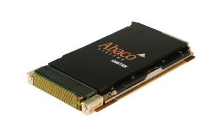
A myriad of new applications for GPS seems to appear each time the technology shrinks in size. Engineers at Rockwell Collins in Cedar Rapids, IA, are working with the Army to take their GPS technology and evolve it for surface ground navigation. “The Army is moving to smartphones, so we’re reinventing GPS for that environment, which is where a stamp-sized product fits in because you can embed it into systems ranging from tactical radios to laser range finders – any micro system for UAVs,” says Al Simon, marketing manager for Rockwell Collins in Cedar Rapids, IA. The company is also working on a GPS device about the size of a hockey puck that provides warfighters with strategic position, navigation, and timing information capability in one tiny device, he adds.
“The drive toward smaller packaging will continue until we reach the size of a pinhead,” Simon continues. “We’re also adding more functionality onto receivers now. Not only can they do GPS processing, but we can add anti-jam embedded electronics onto the card itself.” Rockwell Collins’ Micro GPS Receiver Application Module (MicroGRAM), for example, is the size of a postage stamp.
Unfortunately, as GPS devices get more sophisticated so do the attacks, requiring even more elegant security and anti-jam capability with each new breakthrough.
Spoofing and jamming threats are on the rise
The threat to GPS from jamming or spoofing – disorienting or hacking the positioning system – has been steadily rising during the past few years.
“We’ve seen widely publicized cases of the vulnerabilities of GPS – particularly for commercial unencrypted GPS. But this is causing concern about total reliance upon GPS, so the industry is exploring alternatives,” Simon says.
Rockwell Collins’ military GPS receivers are anchored to the encrypted military signal, which can provide some anti-spoofing protection. “The ability to deal with L1 and L2 frequencies gives us inherent anti-jam capability,” Simon continues. “Then we also provide some assisted anti-jamming for augmented anti-jamming above and beyond what you’d get from just having multiple frequencies. As military GPS receiver providers, we can protect GPS very well – certainly beyond the vulnerabilities of a civil receiver.”
“However, navigation systems of the future are probably going to need multi-sensor capability,” in case GPS capability is taken out by enemy forces, Simon notes.
Sidebar 1
(Click graphic to zoom by 1.9x)
|
|

M-code
M-code, part of the GPS modernization program, is a new signal designed to improve security and anti-jamming of military navigation using GPS, but it will require a level of technology updating because the different frequencies and signals involved will require different antennas.
“M-code is important within the U.S., because it’s the next-generation military GPS that involves civil code – but also encrypted military code,” Simon explains. “Rockwell Collins has been involved in the development of M-code receivers in a prototype sense for several years now, and continues to be involved. M-code is considered to be a big anchoring point for the U.S.”
Current congressional mandates and legislation require any military receiver purchased after fiscal year 2018 to be M-code capable. For this reason, “the whole community is keeping an eye on this, since it isn’t too far off,” Simon says.
It is important to note that M-code is still in the development stage; production receivers for M-code aren’t available yet. “M-code is introducing a whole new layer of security and design complexity. For receivers to become M-code capable, yet remain in the same form factor as the currently used receivers, there’s a degree of technical and design maturity that must improve to move forward,” Simon explains. “We’ll obviously get there, but dealing with M-code and multi-constellation and keeping the same form factor that users have come to appreciate and value is introducing a few technical challenges.”
Combining GPS and IMU technologies
Some military designers are combining GPS receivers with IMUs to establish navigational ‘backup’ for emergency situations and to thwart jamming or spoofing. The general consensus seems to be that GPS and IMUs are simply better together.
In terms of combining GPS and IMU, a hybrid or fused sensor solution really is the best approach, says Jay Napoli, vice president of Fiber Optic Gyros/OEM sales for KVH Industries in Middletown, RI. “Because you can’t jam, fool, or otherwise spoof an inertial navigation system.” It also works underground or underwater, he adds.
While IMUs can be used as a standalone navigation product, “you get a better solution when you integrate it with GNSS; the two systems are simply better together than either one on their own,” Napoli continues.
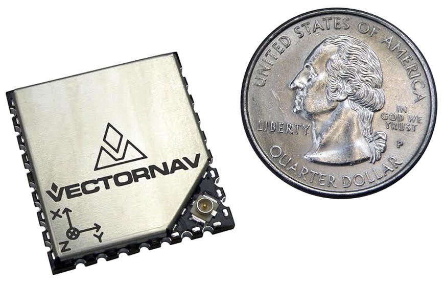
Figure 1: The VN-200 from VectorNav Technologies combines calibrated inertial sensors and GPS for better position, velocity, and accurate orientation.
(Click graphic to zoom by 1.9x)
|
|
Inertial Sensing Units (ISU) or GNSS, or a combination of the two, are enabling the use of sensors in a wide variety of applications that couldn’t have supported them in the past, says James Doebbler, director of R&D for VectorNav Technologies in Dallas, TX. “Since they’ve become smaller and lighter, it’s amazing what we can stick these sensors onto or into these days,” he says.
VectorNav’s GPS-aided inertial navigation system, the VN-200, combines calibrated inertial sensors and GPS for better position, velocity, and accurate orientation (see Figure 1).
“These systems are used on different flying UAV platforms – both fixed wing and multi-rotor,” Doebbler explains. “We also have guided-munitions projects in development right now, in which the common theme is to get smaller cost, size, weight, and power. Many of these small guided-munitions don’t have very large cross sections, but need both positioning and orientation. For smaller unmanned vehicles, weight and power are the big issues. So our VN-200 is in the same footprint and has all the same parameters as the high-end GPS units, but we’ve managed to pack in a lot of benefits by integrating the ISU into it.”