NASA UAVSAR nears mission completion, prepares for Global Hawk port
NewsApril 04, 2013

WASHINGTON. The NASA Uninhabited Aerial Vehicle Synthetic Aperture Radar (UAVSAR) is concluding a month-long scientific mission over the Americas this week, studying questions that range from the dynamics of Earth’s crust to the carbon cycle. The imaging system departed from the Dryden Aircraft Operations Facility in Palmdale, CA, on March 7 aboard a NASA C-20A piloted aircraft, and has conducted research studies over Arizona, the U.S. Gulf Coast, and Central and South America. The NASA Jet Propulsion Laboratory (JPL) in Pasadena, CA built and manages the UAVSAR.
Using a technique that sends microwave pulses from the sensor on the aircraft to the ground called interferometry, the UAVSAR can measure and detect subtle chances in the surface of the Earth. The radar uses L-band microwaves capable of penetrating clouds and forest canopies, essential to topographic mapping.
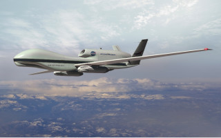
Integration and testing of the UAVSAR onto a Northrop Grumman Global Hawk platform is currently underway. The integration plan includes outfitting the Global Hawk Unmanned Aerial System (UAS) with two wing-mounted UAVSAR pods to enable high-precision topographic map generation and single-pass polarimetric interferometry on vegetation structures. The Global Hawk platform was selected due to its ~14,500 km range and 22-hour nominal flight duration, which could enable campaigns to regions like the Antarctic and long-term observation of events like volcanoes and earthquakes.
More information on the UAVSAR program is available at http://uavsar.jpl.nasa.gov/. More on the integration of the UAVSAR onto the Global Hawk UAS is available at http://opsy.st/UAVSAR-GH and http://opsy.st/UAVSAR-GHPort.