The worldwide market for military satellites and helicopters
BlogSeptember 26, 2024

Ray Alderman
VITA Standards Organization

WARFARE EVOLUTION BLOG. In my previous seven articles, we explored the worldwide markets for most military platforms. However, there are two platforms left to complete our study – satellites and helicopters. I saved these two segments for last since they share some common characteristics. Satellites expend their limited fuel struggling to stay in orbit (station keeping) while helicopters use their fuel thrashing the air furiously with rotor blades to stay aloft. Both fight a constant battle against gravity so that’s why I put them together for this essay. As they say in the aviation community: airplanes want to fly, but satellites and helicopters don’t.
Let’s start with satellites. The numbers mentioned here move around quickly so don’t get attached to them. Both military and commercial organizations are launching satellites frequently. As of July of this year, there are more than 10,000 satellites in orbit. Of those, about 630 are military satellites. The U.S. flies nearly half the military satellites in orbit, about 300. Our European allies are flying a total of about 40. Our Pacific allies only fly six (two from Japan and four from Australia). Space-X has about 6,350 Starlink satellites up there today (63% of the total). They plan to have 42,000 flying when they finish their constellation for worldwide internet service. You’ll see why this is important later.
To read more Warfare Evolution Blogs by Ray Alderman, click here.
Where are all these birds flying and how often do they pass over a point on the earth? About 84% of all satellites flying today are in LEO (low Earth orbit) – around 200 to 1200 miles above the earth). They fly at 17,500 MPH and circle the planet about every 90 minutes, or 16 times per day. Military satellites in this orbit are used for communications and intelligence collection (electro-optical, infrared, radio frequency, and radar). It’s the perfect orbit for earth observation with high resolution. More on this later.
About 3% of all satellites are in MEO (medium Earth orbit) – roughly 3,000 to 12,000 miles high). They circle the earth about every 12 hours and fly at 7,000 MPH. Military satellites in this orbit are used for PNT signals (position, navigation, and timing) like GPS. Other satellites in MEO are used for communications to remote locations like the North and South poles.
About 12% of all satellites are in GEO (Geosynchronous Earth Orbit: about 22,500 miles high). They travel at around 6,700 MPH and stay over one point on the earth. A perfect example is satellite TV. Military satellites in this orbit are used for earth weather monitoring, some communications, and for intercepting enemy communications and radar signals (signals intelligence and electronic intelligence). The rest are in special places like polar orbits, sun-synchronous orbits (SSO), or transfer orbits.
Now that you know where they are and what they do, let’s look at a few military satellite programs underway. The U.S. Space Development Agency is deploying the PWSA (Proliferated Warfighter Space Architecture) under the U.S. Space Force. There are two layers of satellites in the constellation: transport and tracking. The transport layer can move data around in space and to any place on the planet. These birds are the backbone of the Pentagon’s JADC2 (Joint All Domain Command and Control) initiative. The tracking layer satellites detect enemy ballistic and hypersonic missile launches and track them anywhere in the world. So far, about 30 satellites for this program are already in orbit with nearly 1,000 more planned. These satellites communicate with each other, and with ground stations, using lasers so the enemy can’t intercept or jam the signals. The tracking satellites pass targeting date through the transport layer satellites, to the weapons along the enemy missile’s path for intercept.
The next big program is GMTI satellites (Ground Moving Target Indicator) being developed by the NRO (National Reconnaissance Office). This constellation will replace the E-8 JSTARS (Joint Surveillance Target Attack Radar System) flown by the Air Force in old 707 airframes. JSTARS was terminated in 2023. GMTI satellites can track enemy ground vehicles on earth, target them, and then have weapons can hit them in minutes. The number of satellites and the sensors to be used are classified at this point, but it’s not hard to see that electro-optical, infrared, RF Intercept, and radar will be involved.
In early September, the Air Force proposed AMTI (Air Moving Target Indicator), adding new satellites to the constellation that can track enemy aircraft around the world and hit them with weapons in minutes. All these satellites will tie into the JADC2 network, and some of them will go into MEO orbit instead of LEO. GMTI and AMTI will create what it’s like being caught in a “Texas Hailstorm.” The enemy can’t run, they can’t hide, and they can’t stop all the bombs, missiles, and artillery rounds coming down on them.
These AMTI satellites will accomplish some missions presently done by the Air Force AWACS (Airborne Warning And Control System) aircraft flying today.
It will take a while to get all these birds in orbit and operational, so what do the services do until then? They can tap into the existing commercial satellite networks like Starlink, Eutelsat, and Intelsat for communications links (SATCOM). For optical imaging intelligence (IMINT, GEOINT), the services can buy images captured by commercial satellite companies like Maxar and Planet Labs. And they can buy SAR (synthetic aperture radar) images from commercial satellite companies like Iceye and Capella. SAR can see through clouds, rain, fog, snow, smoke, and vegetation. However, there is a limitation with LEO satellites: at 17,500 MPH, they don’t stay over any area very long so they are not good at collecting extensive full motion video of enemy activity on the ground. Consider this example: here in Arizona, our state is 310 miles wide. A LEO satellite traverses our state in 64 seconds. For the state of Rhode Island, it's 8 seconds.
The U.S. Army’s Space and Missile Command is now adopting the new Phoenix-E satellite terminals, that can link into both military and commercial satellite networks, as part of their PACE tactical network plan (Primary, Alternate, Contingent, and Emergency communications links) in contested electronic signal environments like enemy jamming. That has created a flap with the Space Force, who says they have control over all space assets. According to the 1986 Goldwater-Nichols Act, the services (eg, the Space Force) are responsible for the organization, training, and equipping of the forces, but the combat commands control the employment of those resources in operations. So far, the Navy and the Air Force have stayed out of this dispute. The folks at the Pentagon will have to sort this out.
Finally, there’s a Space Force effort called SDA (Space Domain Awareness), to monitor satellite activity and movements in all three primary orbits mentioned above. As satellites become critical sources for military intelligence and communications, our enemies will try to take them out with missiles or killer satellites. The number of SDA satellites for this purpose, and their sensors, has not been disclosed. But electro-optical, infrared, and radar capabilities seem appropriate. Think of these satellites as space cops.
There are many other commercial and military programs ongoing, like satellites that can repair and refuel other satellites in orbit, so you’ll need to do some reading. Altogether, the U.S. military plans to launch about 250 new satellites over the next two years. According to Mordor Intelligence (a market research company), the worldwide market for military satellites in 2024 was $31.97 billion, growing to $53.85 billion by 2029 (a compound annual growth rate of 10.99%). No surprise that most new satellites being launched are going into LEO, for earth observation and communications applications. Smaller countries, that don’t have the money to launch their own satellites, can buy communications links and imaging from the commercial satellite companies mentioned above. That’s what Ukraine has been doing in their war with Russia.
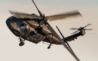
Now, let’s come down closer to earth and look at military helicopters. They are slow, can’t carry many troops, and can't carry much cargo. The big news here is that the U.S. Army has chosen the V-280 Valor tilt-rotor aircraft to replace the UH-60 Blackhawk helicopter, under their FLRAA program (Future Long Range Assault Aircraft). The Valor can tilt its rotors up for vertical take-off and landing and rotate them horizontally for flight.
The Blackhawk can fly at about 185 MPH while the V-280 flies at about 345 MPH. The range of a Blackhawk is 370 miles while the range of the V-280 is 2,400 miles. The Blackhawk can uncomfortably carry 11 fully-equipped combat soldiers to the battlefield while the Valor can carry 14. The Blackhawk can lift about 9,000 pounds of cargo while the Valor can lift about 10,000 pounds. Deliveries of the first V-280s are scheduled for 2031, and they will replace the 2,100 Blackhawks presently in service. They cost about $43 million each. The Marines and Navy already fly the V-22 Osprey, so the tilt rotor aircraft concept is gaining ground over traditional helicopters for certain missions.
The AH-64 Apache attack helicopter is being upgraded regularly. It’s the best tank killer on the battlefield. More than 5,000 Apaches have been built and 18 countries are flying them today. The Army has about 1,300 in service. Poland just bought 96 and South Korea bought 36. The Army has not started competition for an Apache replacement, but the Bell 360 Invictus prototype looks like a good candidate. It’s a traditional helicopter with overhead blades.
Then, there’s the big cargo helicopters like the MH-47 Chinook. South Korea just bought 18, Spain bought one, and the Army has 46 on order. They cost about $115 million each. The UK just bought six medium-lift H145 helicopters from Airbus. Other countries are buying a few military helicopters here and there. In the latest Mordor Intelligence market research report, they say that the worldwide market for military helicopters was $8.60 billion in 2024, growing to $10.21 billion by 2030 (a CAGR of 2.90%). As you can see, the military helicopter market is not that big (relative to the markets for other platforms), and it’s growing more slowly (than the markets for other platforms).
One more thing before we go, to add to your collection of military market data. According to Grand View Research (another market research company), the worldwide market for military sensors was $11.40 billion in 2023, growing to $18.31 billion by 2030 (a CAGR of 6.9%). Unmanned autonomous platforms seem to be a driver of this growth.
So, there you have it. If you perused all the previous articles, you should now have a good perspective of the worldwide markets for all the different military platforms. Now, we need to look at the military budgets of the top countries in the world and tie everything together. But, I'm getting tired of reading market research reports, so let’s do something different next time. We’ll take a look at the new SR-72 MACH-5 airplane, explore why the U.S. Air Force just put a hold on the NGAD 6G fighter plane program, and investigate why the Air Force is looking at a small lightweight fighter plane for their fleet. Then, we’ll come back to the country military budgets and do the recap on the worldwide military markets. That’s the plan.